NULL
The nature surrounding us, the living world, and the ecosystem provide us with the means to produce food. They play an essential role in regulating the climate by absorbing carbon dioxide, storing carbon, or protecting the soil from erosion. In recent decades, the concept of ecosystem services has gained ground. Its spread is due to the opportunity it offers to explore the complex interrelationships between the natural and socio-economic systems. It highlights how society and the economy are based on ecosystems and how human activities modify the natural environment. There is a clear link between the state of ecosystems and the well-being, health and happiness of people through ecosystem services.
Hungary’s current National Biodiversity Strategy to 2030 (3rd National Biodiversity Strategy) was adopted in August 2023. Its objectives are creating a coherent network of protected areas, improving the condition of different protected areas and restoring degraded ecosystems. The above objectives can only be achieved based on proper information and a thorough situation assessment. For this, we need a comprehensive understanding of the current state of our habitats.
Over the past five years, extensive cooperation has been established between sectoral experts and nearly 250 researchers and conservationists in a project coordinated by the Ministry of Agriculture (KEHOP-4.3.0.-VEKOP-15-2016-00001). One project element is the National Ecosystem Services Mapping and Assessment (MAES-HU), which aims to assess and map the extent of ecosystems, ecosystem condition and ecosystem services nationwide. The extensive collaboration resulted in several studies, which amounted to about 2,400 pages overall. The most important results are highlighted in a book titled ‘The Assessment and Mapping of Ecosystem services in Hungary’.
“One of the tasks was to assess ecosystem condition. However, what someone means by the condition of an area or habitat can be very varied,” says Eszter Tanács, one of the project researchers and a research fellow at the HUN-REN Ecological Research Centre. “Each stakeholder defines ‘good condition’ from their own perspective. They usually focus on factors that directly affect the state of the habitat or group of organisms that are especially important to them. For example, the health of plants (whether trees or crops of some kind) is an important indicator. If this is not in order, everyone pays attention. However, there may also be indirect links between condition and services that are more difficult to identify. For example, the diversity of wildlife in an area may be closely linked to its condition and thus indirectly to what services may be provided by the particular ecosystem type and in what quality.”
“To inform nationwide decisions, we need to produce maps that try to reflect the state of the environment and habitats nationally. This scale represents a particular challenge because the ‘goodness’ of large-scale maps depends to a large extent on the data we can base them on. However, how much detailed data we have for a given area is often arbitrary in space and time. Information on different types of habitat is not uniformly available. In the case of forests, where management means that we have to think in terms of decades or centuries, a lot of data are available at the national level. This is also true for agricultural land, partly due to the different subsidy schemes. For grasslands and wetlands, however, there is little information at the national level based on accurate measurements, although many sectors could make good use of such. Generally, more related information is available on very valuable protected areas, but these cover only a small part of the country’s territory,” said Eszter Tanács, explaining the difficulties of the task.
“Where there are insufficient sources of information, i.e. little measured data, the researchers have tried to indirectly estimate the extent of environmental pressures and mapped them. They have built on previous research and knowledge of responses to such pressures. Maps based on such relationships can also be used to estimate current condition and suitability for wildlife. Still, they have a relatively high degree of uncertainty because they represent risk. There are cases where only rough estimates can be provided through multi-step analyses – for example, flower abundance is estimated based on the presence of pollinators, and flower abundance is estimated based on what habitat is being discussed. The usefulness of such maps is more limited than those based on measured data. Therefore, an important element of our research is to investigate how well such maps reflect the condition according to more detailed, fine-scale data where they are available. This is a prerequisite for producing better and more accurate maps over time,” said Eszter Tanács.
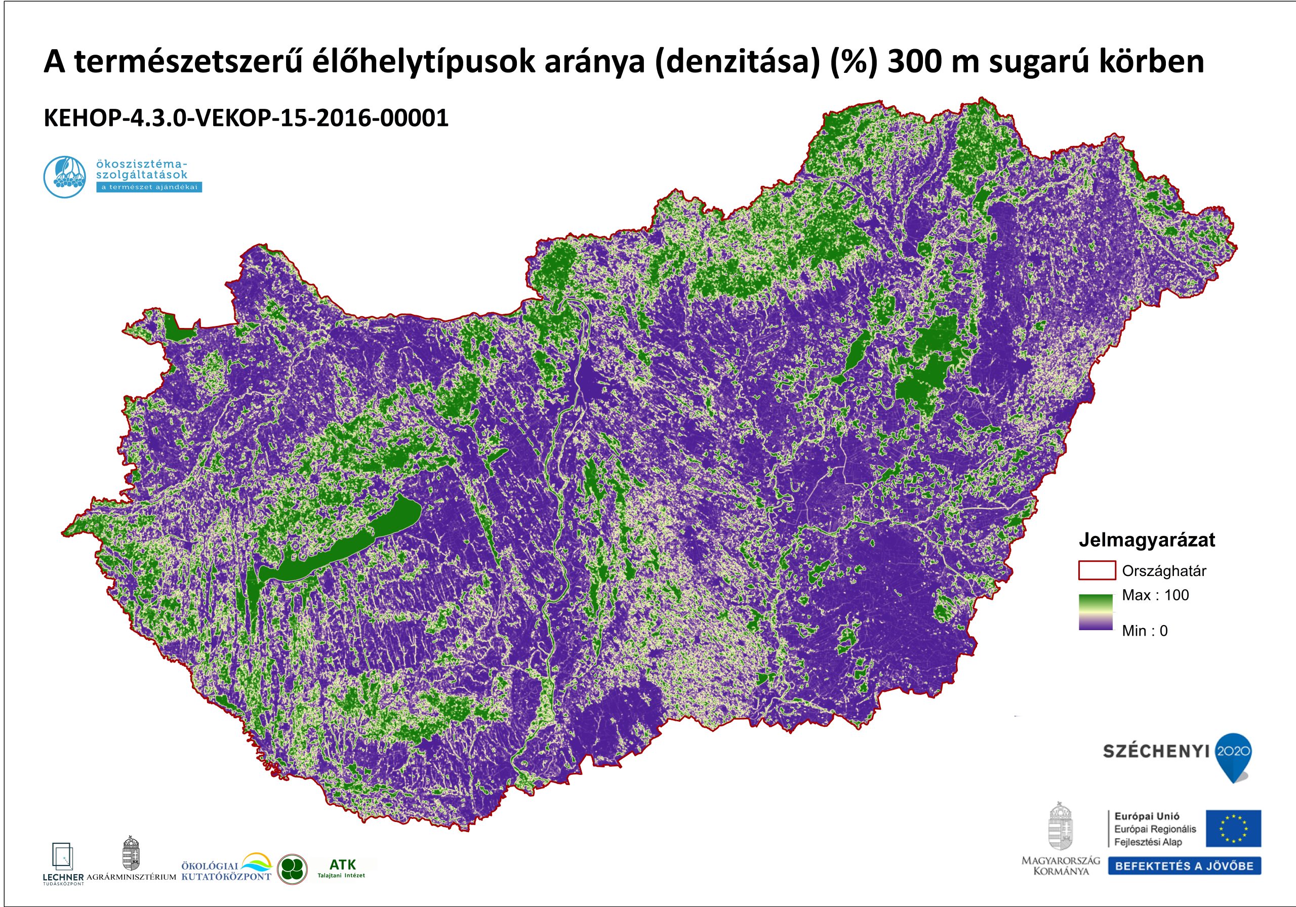
The Ecosystem Map of Hungary, completed in 2019 (with a baseline year of 2015), was a major milestone in the implementation of the project. Although there were significant data gaps in some of the maps used for compiling it, a detailed, wall-to-wall land cover database has been developed. It is currently the best available for Hungary in terms of spatial and thematic resolution.
Researchers from the HUN-REN ÖK Lendület Ecosystem Services Research Group have reviewed European ecosystem services mapping projects using national experience in a recent prestigious international publication. The paper, published in the journal Ecosystem Services and first authored by Ágnes Vári, reviews the ecosystem mapping process in 13 European countries, presenting the results of a survey of project participants. The publication reviews the types of methods used, the ecosystem services assessed, the problems identified, and possible ways forward at the European level.
Publication:
Ágnes Vári, Cristian Mihai Adamescu, Mario Balzan, Kremena Gocheva, Martin Götzl, Karsten Grunewald, Miguel Inácio, Madli Linder, Grégory Obiang-Ndong, Paulo Pereira, Fernando Santos-Martin, Ina Sieber, Małgorzata Stępniewska, Eszter Tanács, Mette Termansen, Eric Tromeur, Davina Vačkářová, Bálint Czúcz: National mapping and assessment of ecosystem services projects in Europe – Participants’ experiences, state of the art and lessons learned
Ecosystem Services, Vol.65, 2024, https://doi.org/10.1016/j.ecoser.2023.101592
