
NULL
One of the effects of climate change is shifting the habitats of species. For example, warming is pushing upward the forest boundary in high mountains. The question is whether the species’ speed of spreading is fast enough to follow the suitable habitats. Dr. Beáta Oborny, a researcher from the Institute of Evolution at the Centre for Ecological Research and the Institute of Biology at the Eötvös Loránd University, together with her colleagues have developed a new method to investigate this. Their paper co-authored with Dániel Zimmermann was the editor’s choice in Ecography. (The editor’s choice is a paper highlighted as the most exciting and novel paper in the monthly journal issue.)
As our planet undergoes significant transformations due to climate change, habitats are being altered, appearing, disappearing, or changing in quality. Understanding the impact of these changes on the geographic distributions of species is of great significance. The shrinking ranges of protected organisms and the expanding ranges of noxious species, such as pests and pathogens, highlight the urgent need to monitor range movements precisely. However, this task poses challenges as the available observation time is often short compared to the pace of underlying population processes, making it difficult to distinguish between directional shifts and random fluctuations.
Addressing this challenge, a research team led by Dr. Beáta Oborny from Loránd Eötvös University and the Centre for Ecological Research in Budapest has developed a novel method to monitor range shifts. The team aimed to precisely and consistently delineate range edges, allowing for comparisons between different years, geographic locations, and species.
Delineating range edges accurately is a non-trivial task as they often exhibit complex patterns. Occupied peninsulas are interspersed with unoccupied bays, and isolated occurrences dot the landscape. While traditional methods rely on the outermost occurrences of a species, Oborny and her colleagues propose a different approach. They suggest marking the range edge at the boundary between connected and fragmented occurrences, known as the “hull.” By marking the average position of the hull, the “connectivity limit,” over time, the researchers offer a statistically more reliable method. This region has a higher population density and exhibits smaller fluctuations, enhancing the robustness of the approach.
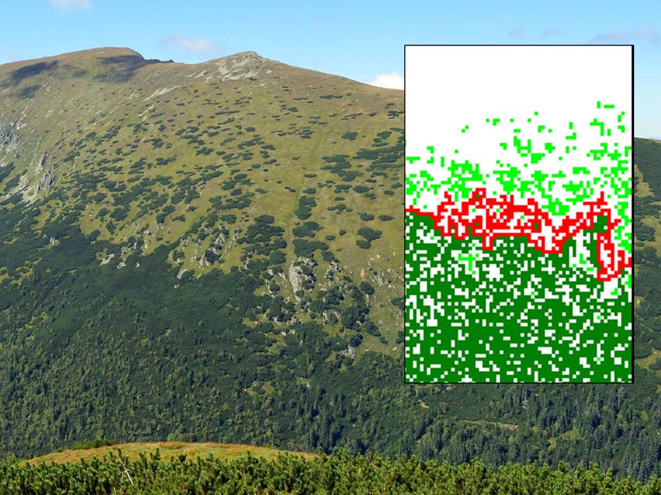
Photo: Courtesy of Konrád Lájer simulated image: Beáta Oborny
Oborny and her colleagues delved into the pattern-generating mechanisms using spatially explicit models. Unlike previous approaches based on general spatial statistical methods, their novel approach capitalizes on knowledge about the mechanisms governing the emergence of these patterns: birth, dispersal, and death within populations. Through computer simulations along environmental gradients (e.g., hillsides), the team explored the connectivity limits of different kinds of species. Remarkably, they discovered that the hull displayed a robust fractal structure with a dimension of 7/4. Further investigations conducted by Beáta Oborny and Dániel Zimmermann confirmed that this fractal structure remained consistent regardless of whether the range was rapidly advancing or retreating compared to the generation time. Notably, the method demonstrated particular robustness in the retreating (trailing) edge of species ranges. These findings highlight the applicability of the connectivity limit in tracking range shifts across diverse geographic scenarios, enabling a global perspective on these changes. For instance, the method allows for the comparison of treelines in different mountains, even when composed of different species, utilizing universal scaling laws.
The universal features uncovered in this study find their explanation in percolation theory, a field of research in statistical physics. This exemplifies the power of knowledge transfer between seemingly disparate scientific disciplines. The insights gained from these investigations deepen our understanding of the intricate relationship between environmental changes and species distributions. As scientists continue to refine and validate this method, it holds the potential to contribute to more robust assessments of biodiversity shifts and inform effective conservation strategies.
Image: An upper limit of Dwarf mountain pine (Pinus mugo) in the low Tatra Mountains, Slovakia. The inset shows a snapshot from simulated population dynamics. Dark/light green shows the connected/fragmented occurrence of the species. The hull is marked by red.
Photo: Courtesy of Konrád Lájer simulated image: Beáta Oborny
